|
||||||||||||


 |
Utah State's back yard . . . my third home, and one big enough to get lost in (literally) Tex
and photos by Dusty Decker
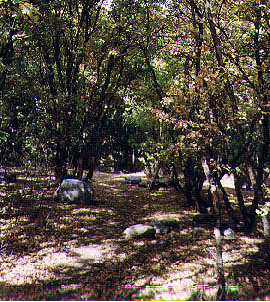
With some ease we hefted the large backpacks onto our sturdy shoulders and after fidgeting with many strap adjustments, I looked at my roommate, Claudia, and was ready to embark on my first Logan Canyon backpacking experience. The sky showed only sunlight and blue, a relief after countless days of rain that encouraged us to have our rain suits stowed deep in our packs. We felt qualified to accurately follow the established trail without concern for mishap. Saturday, Sept. 2, we had visited the Forest Service Station just at the mouth of Logan Canyon. The woman there was unfamiliar with the trail we wanted to backpack from Tony Grove to Green Canyon, but she told us that we would have no problem if we had a 7 1/2 minute map and a compass. Since our only navigational device on hand was a key chain with a compass the size of my thumb nail, we chose to drive to Trailhead on Main Street to purchase two 7 1/2 minute maps and a compass. We also bought a Wasatch-Cache National Forest map of Ogden and Logan Ranger Districts at the Forest Service Station--a map I encourage anyone to own who wants to find their way in Logan Canyon. Finally we were completely ready for our journey with my car waiting for us at the bottom of Green Canyon. Green Canyon is at 1600 East and 1900 North in North Logan. It's an excellent place for quick horseback riding, mountain biking, hiking and camping trips. The trail up Green Canyon eventually meets Mount Naomi Wilderness where bikers, of course, cannot venture. Bridgerland's guide pamphlet for hiking trails suggests that you start at Green Canyon and go to Tony Grove. Perhaps we should have considered that suggestion in our planning, but which way we went seemed irrelevant in the beginning.
Despite warnings from the woman at the ranger station that people often get lost in Cottonwood Canyon, and the warnings in the guide pamphlet that the trail can be easily lost due to numerous sheep trails and avalanche debris chutes that intersect it, we felt confident. The backcountry trailhead begins just before you get to Tony Grove Lake approximately 25 miles from Logan. We found the place inhabited by many horse trailers and nice people who said "hi" as we passed. One man warned, "you're going to get cold up there," but this did not concern me. I will admit the urge to borrow a horse and throw my pack on top of it was tempting, but we were fresh and ready for a Labor Day weekend adventure. We followed the brown wooden signs that took us near Coldwater Spring and then turned toward Cottonwood Canyon. Our main landmark destination for the night was Mount Elmer. We easily found the sign for Mount Elmer and that seemed good enough even though we were uncertain of its location. We had left at 12:30 p.m. and we stopped to set up camp around 6 p.m. The only uncertainty was of how much distance we had left to cover. We knew the trail was 12 to 14 miles, and we were confident that we would reach my car before 2 p.m. the next day.
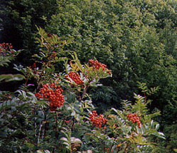
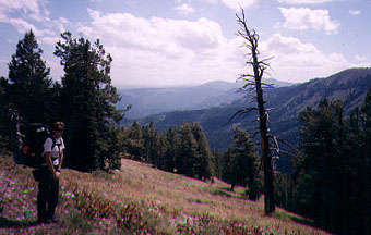
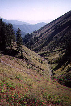
To describe the feeling of being in the mountains catches my breath and expels a deep sigh of satisfaction. Although the trees were still green, a hint of fall could be found in quiet bird chirps, cool air and lack of mosquitos. The few clouds we did see rapidly passed, reminding us that we were between 8,000 and 10,000 feet above sea level. Tony Grove is part of the "high country" and remnants of glaciers, such as piles of rocks called moraines and rounded bowls called cirques, can be seen. Tony Grove is a magnificent area. It has been called the "crown jewel" of the Bear River Range, and is historically known for the Tony Grove Ranger Station, a log cabin built in 1907. Wildflowers flourish in the summer and reach their peak at the end of July. Although they become scarce in September, we did see Indian paintbrush, lupine, sticky geranium, yarrow, chokecherries and snowberries. You can also find many conifer trees such as Engelmann spruce, Douglas fir, limber pine and lodgepole pine. On the trail we saw signs of coyote, elk and deer. We even came across some ruffed grouse that repeatedly flew up as we walked along the trail. Perhaps the most remarkable animal we saw was the juvenile red-tailed hawk. I envied the way its long wings remained firm as they caught the thermals that drifted the bird higher into the air. The most amazing thing about backpacking is that you suddenly realize how relaxing it is to be separated from the ongoing world. The music of silence steals your mind away and the freshness of life all around you tantalizes your senses. To consider that this place once had no roads seems strange. The first person to write any record of Logan Canyon was Warren Angus Ferris in 1830. He commented on the numerous grizzly bears and mountain sheep he saw. Until the 1850s, travel between Cache Valley and Bear Lake was difficult. The last grizzly bear was shot in 1923 and the canyon has further been marked by road building, lumbering, livestock grazing, mining and modern recreation. The Forest Service does a great job of maintaining more than 50 trails that vary in degree of difficulty ranging from 5,000 to 10,000 feet. The designated Mount Naomi Wilderness preserves a pristine part of Logan Canyon. As we arose Sunday morning from a long, cozy sleep we found ourselves swept away in the beauty of the morning. By 8:30, a little later than planned, we headed toward the direction of Mount Elmer. Our guide information distinctly explains how the trail climbs just below the summit of Mount Elmer and circles around the side of it. Somehow we overlooked that. After climbing some nice switchbacks we could see the landscaped valley of Logan, but we continued on the trail which might have split somewhere because suddenly we were headed back down. I convinced myself that there was no other way we could have gone and we continued, but grew uneasy when we ran out of trail to follow. We continued down the canyon we were in, but footing was more difficult and the traveling was slow and even painful. Maps were consulted with regularity and the compass around my neck became my friend. Finally we realized we were headed southeast away from our destination and into South Fork Canyon. We needed to be heading southwest into Green Canyon. Despite the panicky tone of my roommates voice, I was surprisingly calm. We agreed to backtrack some and then make our way up an unknown ridge.
There is a feeling of being lost that is amazing. We didn't panic but slowly made our way, promising ourselves that we were getting closer to something. Upon reaching the top, we could again see the valley and the trail wriggled under our feet as if it had always been there. We dropped our packs and trotted back along the trail that indeed traveled around Mount Elmer. Even though it was almost 5 p.m. we knew how to reach our destination. Above us soared the hawk we had seen before getting lost. Around 7:30 we passed the wilderness sign in Green Canyon and by 8:30 we arrived at my car with sore feet, bruised hips and shoulders and aching bodies. At home our fellow roommates greeted us and we shared in our remarkable tail of getting lost and how our technical map skills led us back home. I found myself more appreciative of Logan Canyon and realized that I now belonged to a part of it. Not only had we ventured into Mount Naomi Wilderness, but we also gained insightful knowledge. Introspection left me with the feeling of satisfaction and a desire to always find my way out of unknown canyons despite the difficulty of the way before me.
|
Archived Months:
January
1999 January
2000 |
||||||||||